Bengaluru : Weather conditions across the state of Karnataka continue to fluctuate as several districts witness changing atmospheric patterns. During the last 24 hours, many regions of the state received moderate to good rainfall, bringing temporary relief from rising temperatures and dry conditions.
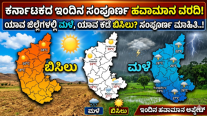
According to rainfall observations, the highest rainfall was recorded in the Rattihalli region under Hiremoraba limits of Haveri district, where nearly 52 mm of rain was reported. Other parts of central Karnataka also experienced scattered rainfall, cooling the atmosphere after days of heat.
Meanwhile, weather experts indicate that cloudy conditions are expected to continue across coastal and Malnad regions, with chances of evening thunderstorms and light to moderate rainfall over the next few days. The changing weather pattern is also being closely monitored because the southwest monsoon winds are expected to become more active over the Arabian Sea and the Indian Ocean in the coming weeks.
Rainfall Activity Across Karnataka
The latest rainfall data reveals that several regions in Karnataka have experienced isolated showers and thunderstorms. While rainfall distribution has remained uneven, many districts in central and coastal Karnataka witnessed beneficial rain. The rainfall brought down daytime temperatures slightly and created pleasant weather conditions in many areas.
The highest rainfall during the last 24 hours was recorded in the Rattihalli area of Haveri district. Other neighboring regions also reported moderate showers, especially during late evening and nighttime hours. Weather officials suggest that the current weather activity is a result of moisture accumulation over the western coastal belt combined with local atmospheric instability.
Although the rainfall has not been widespread across all districts, isolated thunderstorm activity is likely to continue in selected areas over the next few days.
Coastal Karnataka Expected to Receive More Rain
The coastal districts of Karnataka are likely to continue experiencing cloudy skies and intermittent rainfall. Districts such as Mangaluru region in Dakshina Kannada, Udupi, and neighboring Kasaragod are expected to receive light to moderate rain accompanied by thunder and lightning in isolated places.
Meteorologists believe that areas located near the foothills of the Western Ghats may receive comparatively higher rainfall intensity during evening hours. Residents living in low-lying and coastal regions may witness rain either late at night or during the early morning hours.
In parts of Karwar and regions bordering Belagavi district, evening showers are also likely. However, forecasts indicate that rainfall activity along the coastal belt may gradually reduce after May 11, leading to relatively drier weather conditions in the coming days.
Even though heavy rain is not expected everywhere, occasional thunderstorms accompanied by gusty winds may continue in isolated coastal pockets. Fishermen and residents near the coastline are advised to stay alert during thunderstorm periods.
Malnad Region to Witness Cloudy Weather and Isolated Showers
The Malnad region, known for its hilly terrain and lush greenery, is also expected to remain under cloudy conditions. Several areas in Madikeri district may receive evening thunderstorms along with scattered rainfall.
However, regions around Somwarpet and Shanivarasanthe are likely to experience comparatively less rainfall activity. Weather experts suggest that rainfall distribution in Kodagu district may remain uneven, with some places receiving brief showers while others remain mostly cloudy.
Districts such as Hassan, Shivamogga, and Chikkamagaluru are expected to witness cloudy skies and mild weather conditions during evening hours. In a few locations closer to the coastal side of Chikkamagaluru district, light rainfall may occur.
At present, weather models indicate that rainfall activity over Malnad districts may begin reducing gradually after May 11. Until then, residents can expect occasional clouds, cool breezes, and isolated showers in select areas.
North Interior Karnataka to Continue Facing Heat
Unlike coastal and Malnad regions, most districts of North Interior Karnataka are expected to continue experiencing hot daytime weather. Dry conditions are likely to dominate several regions, although isolated cloud cover may develop during evening and nighttime hours.
Only a few places near the border areas of Belagavi district adjoining Uttara Kannada may receive light evening showers. Apart from these isolated pockets, significant rainfall is not expected across most northern interior districts.
The weather department also notes that temperatures may remain above normal in some areas due to strong daytime heating. Residents are advised to avoid prolonged exposure to direct sunlight during afternoon hours and stay hydrated.
Cloud formation during evenings may provide temporary relief, but widespread rain activity is currently not expected in this region.
South Interior Karnataka Likely to Remain Mostly Dry
Districts in South Interior Karnataka, including areas surrounding Bengaluru, are expected to witness a mix of sunshine and cloudy weather conditions. Forecasts suggest that rainfall chances will remain relatively low across most south interior districts for the next few days.
Although isolated cloud development may occur during evening hours, widespread rain is unlikely until at least May 13. The weather is expected to remain warm during daytime hours, especially in urban centers.
However, occasional cool winds and cloud cover may provide temporary relief from rising summer temperatures in some locations. Residents can expect generally stable weather conditions with limited rainfall activity.
Atmospheric Changes Influencing Karnataka Weather
Meteorologists are closely monitoring several important atmospheric developments that may influence weather patterns over South India in the coming days.
Possibility of a Low-Pressure Circulation
Weather experts have indicated that a cyclonic circulation or low-pressure-like system may develop near the Tamil Nadu coast around May 11. However, current projections suggest that the system may weaken gradually after formation.
Even though the system may not intensify significantly, it could contribute to moisture movement toward parts of Karnataka and neighboring states, leading to isolated rainfall activity in coastal and southern regions.
Such atmospheric circulations are common during the pre-monsoon season and often trigger thunderstorms and scattered showers across peninsular India.
Southwest Monsoon Signals Becoming Stronger
One of the most important weather developments is the expected strengthening of southwest monsoon winds over the Arabian Sea and the Indian Ocean from around May 15 onward.
Meteorologists believe that the gradual activation of monsoon currents is an encouraging sign for the upcoming rainy season. Farmers across Karnataka are especially hopeful that timely monsoon advancement will support agricultural activities after weeks of fluctuating summer weather.
The southwest monsoon plays a crucial role in Karnataka’s agriculture, water supply, and reservoir levels. Early signs of strengthening wind patterns over the ocean are often considered positive indicators for seasonal rainfall progression.
Although it is still too early to predict exact rainfall distribution for the monsoon season, current atmospheric trends suggest favorable conditions for the gradual advancement of monsoon systems.
Precautionary Measures During Thunderstorms
As many districts continue to experience unstable weather conditions, authorities advise residents to remain cautious during thunderstorms and lightning activity.
People living in coastal and hilly regions are encouraged to:
- Avoid standing under trees during lightning
- Stay indoors during intense thunderstorms
- Disconnect electrical appliances during lightning activity
- Avoid unnecessary travel during heavy rain
- Monitor local weather updates regularly
Farmers are also advised to take precautions while working in open fields during periods of thunderstorm activity.
Relief From Heat in Several Districts
The recent rainfall has brought noticeable relief from intense summer temperatures in many parts of Karnataka. After several days of dry and hot weather, moderate showers have improved atmospheric conditions and lowered temperatures in select districts.
Cloud cover and evening rain have created cooler nights, especially in central and coastal regions. While dry weather continues in some northern and southern interior areas, the possibility of isolated showers may still provide temporary respite from the heat.
Weather Outlook for the Coming Days
Overall, Karnataka is expected to witness mixed weather conditions over the next several days. Coastal and Malnad districts are likely to continue receiving scattered rainfall and thunderstorms, while interior regions may experience warm weather with isolated cloud activity.
Rainfall intensity is expected to reduce gradually after May 11 in many regions, especially along the coast and hilly districts. However, the strengthening of monsoon-related winds over the Arabian Sea after May 15 is being viewed as a positive sign for the approaching monsoon season.
As weather systems continue to evolve, residents across Karnataka are advised to stay updated with local forecasts and remain prepared for sudden changes in weather conditions.