This article will guide you through the Mojini v3 platform key features, benefits, login and registration processes and how to check application and allotment status online. E-governance has transformed the way citizens interact with government services, eliminating tedious processes and ensuring better accessibility. The Karnataka Government has been at the forefront of adopting technology to streamline public services, particularly land-related affairs. Introducing Mojini v3, a modern solution built to simplify the land recording system for the citizens of Karnataka.
Overview of Mojini v3 Portal Karnataka
| Feature | Description |
|---|---|
| Launched by | Revenue Department, Government of Karnataka, India |
| Function | Software for processing and managing land-related permits and information |
| Key Feature | Transparent, automated permit issuance with FIFO (First In, First Out) process |
| Official Website | https://bhoomojini.karnataka.gov.in/ |
| Track Application Status | Check the status of land-related applications using application number, mobile number, or survey number. |
| View Allotment Status | View details about the status of land allotments. |
| Land Sketches | Access sketches such as 11E, Alienation, and Phodi sketches. |
| Revenue Maps | View detailed maps to understand land locations within villages. |
| Dispute Cases | Access reports related to land disputes and management systems. |
What is Mojini v3?
The Mojini project is an initiative by the Department of Revenue, Karnataka, aimed at making land-related services transparent, efficient, and user-friendly. Through Mojini, citizens can access critical resources and resolve land concerns right from their smartphones.
With its advanced features, Mojini eliminates the need for multiple office visits, offering efficiency and simplified processes for tasks such as tracking land records, application statuses, and accessing land sketches.
Key Features of Mojini v3
With Mojini, users can enjoy a range of impressive functionalities that empower their interaction with land services:
1. Track Application Status
Users can track land-related application statuses simply by entering their application numbers. This feature helps users know exactly where their applications stand without the need for follow-ups.
2. View Allotment Status
Have you been allotted a tract of land or waiting for an update? Mojini allows you to monitor the allotment status online, ensuring real-time updates on allotment stages.
3. Access to Land Sketches
Visualize and retrieve detailed land sketches through the app:
- 11E Sketch (Pre-Mutation Sketch)
- Alienation Sketch
- Phodi Sketch (necessary for land division processes)
4. Revenue Maps
The app provides access to revenue maps of village lands, allowing users to visualize land layouts and boundaries easily.
5. Dispute and MIS Reports
Citizens can access data about ongoing land disputes and centralized MIS reports, making dispute resolution more transparent.
6. Circulars and Updates
Stay informed with the latest updates, circulars, and changes in land policies directly through the app.
Mojini v3 is the latest and enhanced version of the Mojini framework. Designed with user feedback in mind, Mojini v3 focuses on transparency, efficiency, and simplified processes such as FIFO (First-In-First-Out) issuance.
Benefits of Using Mojini v3
Why should you consider Mojini for accessing land records? Here are some compelling reasons:
- Transparency in Processes: Mojini eliminates the guesswork involved in tracking land applications.
- Improved Accessibility: Access land services and vital records from virtually anywhere.
- Efficient Time Management: Time-consuming office visits are replaced with seamless digital processes.
- Centralized Data: Gain access to all land-related information and updates in one place.
- Empowerment for Users: Citizens can take ownership of their land records without requiring intermediaries.
How to Check Mojini v3 Application Status
Follow these simple steps to check the status of your Mojini v3 application:
Visit the Mojini v3 Official Website:
Go to the official Mojini v3 portal.
Click on ‘Check Application Status’:
Locate and click on the option to check your application status.

Choose a Method to Check Status:
You can check your application status using any of the following methods:
Using Application Number

- Enter your application number.
- Click on the ‘Get Status’ button.
- After clicking, your application status will be displayed.

- Click on the ‘Track Status’ icon for a detailed view.

Using Registered Mobile Number
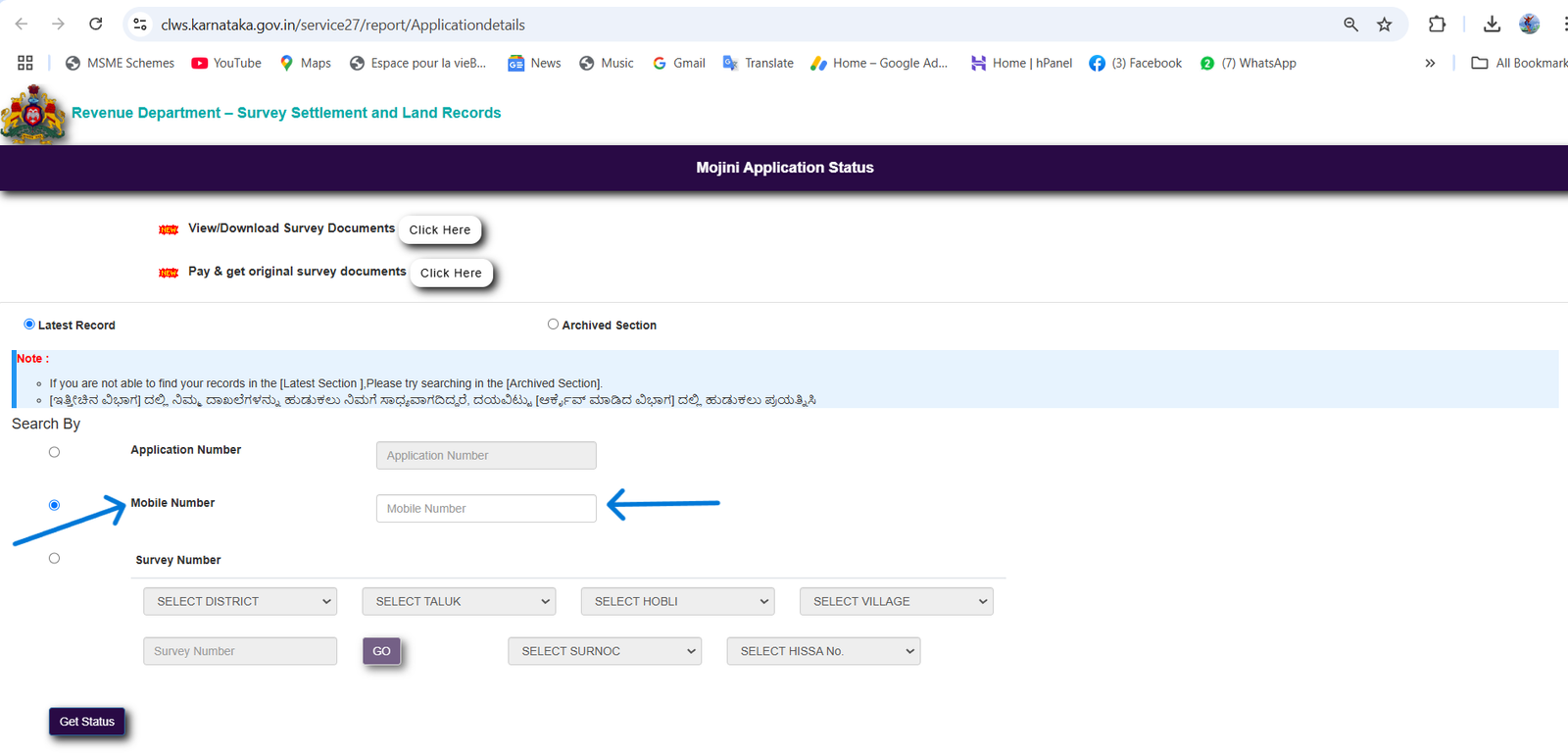
- Enter your registered mobile number.
- Click on the ‘Get Status’ button.
Using Survey Number

- Select your district.
- Select your taluk.
- Select your hobli.
- Select your village.
- Enter the survey number (Surnoc).
- Enter the hissa number.
- Click on the ‘Get Status’ button to view your application details.
How to Login to Mojini v3
- Visit the official Mojini website at bhoomojini.karnataka.gov.in.

- Click on the Login section.
- Enter your account details (username and password).

- Access various sections, including application tracking and land records.
How to view 11E Sketch
The 11E Sketch is vital for pre-mutation processes, and Mojini makes it incredibly simple to access:
Steps to View the 11E Sketch
- Open the Mojini app and log in.
- Navigate to the “Land Sketches” section.
- Select 11E Sketch and input the required details.

- View or download the sketch as needed for your application or records.
Here are the two steps after installation of application:
- Enter Reference Number Manually:
Locate the field to enter the survey or reference number for the land record. Input the number you have and click to proceed. - Select from Previous Applications:
If you’ve previously used Mojini to track an application for this land record, a list of past applications might be available. Choose the relevant application from the list for quick access.
Once you proceed, the land record sketch (map) will be displayed on the app.
Gruha Lakshmi Yojana 2025: Step-by-Step Registration and Details
Mojini is a remarkable example of leveraging technology to address real-world challenges in land governance. It enhances transparency, reduces delays, and empowers Karnataka’s citizens by making land-related services seamless and efficient.
With features like real-time tracking, easy sketch access, and robust transparency mechanisms, Mojini is redefining land records’ management for the better.
For further details and access to Mojini’s complete feature set, visit the official website today at bhoomojini.karnataka.gov.in.


Good information sir..
Thank you..